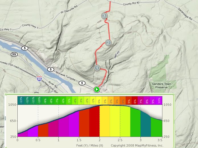
Monday, October 11, 2010

Gower Road


Distance: 2 miles
Climbing: 500 feet

Another nice climb in the Scotia-Glenville area, not far from the Sanders Preserve, Gower Road has several very steep pitches in the first 1/3 mile, with a few sections exceeding 15% grade (not visible on the elevation profile), and finishes with a moderately steep grind to it's termination at the intersection with Sanders Road.

Friday, October 8, 2010

Carrick Road from Altamont via Old Stage Road


Distance: 2.6 miles
Climbing: 910 feet

The climb to Carrick Road from Altamont via Old Stage Road consists of very steep pitches with just enough moderation in between to allow recovery. I've done this climb a few times on both a road bike and a single-speed mountain bike. The advantage of riding a mountain bike is that you can ride the excellent singletrack which is accessible via the Carrick Road trailhead. The singletrack winds it's way back and forth along the escarpment and enters Thacher Park. The climb as described begins at the Stewart's shop at the intersection of Route 156 and Main Street in Altamont. Climbing the very steep Helderberg Avenue (behind Stewarts) shortens the ride on 156 (which can be busy- use caution). The climb then turns left on Old Stage Road, and after another left turn ends at the high point on Carrick.

Thursday, October 7, 2010

Bly Hollow Road


Distance: 2.7 miles
Climbing: 930 feet

Bly Hollow Road, located off of Route 22 near Cherry Plain State Park, is definitely a test. It's mostly dirt and you get to ride through the middle of a stinky cow farm. The grade is steep (some riders may find themselves wishing for a triple ring) and the shotgun-toting rednecks may or may not be friendly to men (or women) wearing brightly colored spandex. On the plus side, you'll ride it fast.

Wednesday, October 6, 2010

Lake Shore Road


Distance: 1.3 miles
Climbing: 410 feet

Lake Shore Road is a small and deceptively steep dirt road climb with a great view of the Tomhannock Reservoir in Pittstown. When riding east on Route 7, take a left on the dirt road just before the causeway. Enjoy the climb and the view.

Tuesday, October 5, 2010

Pattersonville-Rynex Corners Road


Distance: 3.3 miles
Climbing: 940 feet

Another nice climb located off Route 5S in the Rotterdam Junction-Mariaville Lake area, Pattersonville-Rynex Corners Road offers a slightly longer and less difficult alternative to the top of the ridge than Crawford Road. Don't worry, you'll find that it's still steep and long enough, as you grind your way up close to 1000 feet of vertical.

Monday, October 4, 2010

Platte Clove Road- Devil's Kitchen


Distance: 2.2 miles
Climbing: 1280 feet

I should begin by saying that I've never ridden this climb- not yet, anyway. Platte Clove Road, aka Devil's Kitchen, is quite possibly the most hellacious climb in New York State, and one of the most difficult climbs in the Northeast, with over 1200 feet of climbing, most of it steeper than 12% grade. Several sections exceed 22% grade as the climb ascends the north side of Platte Clove. The climb was used in the 1990 Tour de Trump, where it gained notoriety when several pro riders, without the benefit of compact cranks, were forced to get off their bikes and walk. The climb was featured in Stage 2 of last year's Tour of the Catskills. The climb begins south of the town of Palenville at the intersection of County Route 33 and West Saugerties Road. Note that access to the road is seasonal and it is officially unmaintained from November 1 to April 15.


Friday, October 1, 2010

Sterling Road


Distance: 1.6 miles
Climbing: 560 feet

The first time I ever heard of the Sterling Road climb, my friend Karl was telling me about a killer climb in the Pattersonville-Rotterdam Junction area, on the way up to Mariaville Lake, that was steep enough that it couldn't be climbed without traversing back and forth across the road. Located between Ennis and Dennison road, will all of the climbing loaded into the beginning, the Sterling Road climb will not disappoint.

Thursday, September 30, 2010

Waters Road


Distance: 2 miles
Climbing: 760 feet

One of the more challenging Scotia-Glenville road climbs, Waters Road climbs steeply upward from Route 5 for two miles, before plummeting abruptly to intersect West Glenville Road. This one is fun in both directions, and can be combined with other challenging climbs in the area for a truly brutal climb fest.

Wednesday, September 29, 2010

Lake Desolation Road


Distance: 4 miles (approx.)
Climbing: 1000 feet

While not as steep as some of the climbs in the area, Lake Desolation Road, located in Middle Grove, offers over 1000 feet of honest climbing at grades which approach 10%. As an added incentive, this is the only climb in this area that I am aware of which has a lake AND a cyclist-run bar at the top. Stop by Tinney's Tavern- they're super friendly and it's a cool place to have a beer without getting thrown out for wearing lycra. Tinney's hosts Lake Desolation Road hill climb races several times a year- the Annual Fall Hillclimb Challenge is October 10th.

Tuesday, September 28, 2010

The Berlin Wall (Plank Road)


Distance: 2.8 miles
Climbing: 900 feet

Rising nearly 900 feet above the town of Berlin, The Berlin Wall offers a steep and relentless climb for Rensselaer County riders searching for a little pain. The climb begins in Berlin, at the intersection of Route 22 and Plank Road. With a brutal, sustained pitch in excess of 10%, the climb lives up to it's name. There's only one way to get to the west from Berlin.

Monday, September 27, 2010

Filkins Hill Road


Distance: 1 mile
Climbing: 460 feet

Filkins Hill Road is another classic, brutally steep Helderberg climb located near the town of Berne, just off Route 443. The middle section is a wall. My only attempt at this climb resulted in failure; I was chased by a big dog while grinding my way up the steepest part of the climb. Fortunately, it was easy to make a fast descent and the dog never had a chance. Rider beware.

I'll be back to try this one again.

Friday, September 24, 2010

Grant Hill Road


Distance: 1 mile
Climbing: 300 feet

A climb doesn't have to be big or particularly difficult to be fun. Located in Guilderland, just off Route 155 and Route 20, Grant Hill Road rises almost 300 feet above the Norman's Kill with a dramatic view of the gorge and a few moderately steep pitches to keep things fun for the hammerheads. Non-climbers will find this one challenging but not impossible.

Next Monday's climb will be a good one- off to the Vermont 50.

Thursday, September 23, 2010

Sickle Hill Road


Distance: 1.5 miles
Climbing: 860 feet

Sickle Hill Road, affectionately dubbed "Sick Hill" Road due to its savage elevation profile, is located off Switzkill Road, in the hills southwest of the town of Berne. With over 850 feet of elevation gain in 1.5 miles, one local rider said Sickle Hill was "the hardest climb he had ever done- around here." If you ride it, keep in mind that there is plenty of climbing to be done just to get to the climb. As the Haitian saying goes- "Beyond the mountains there are more mountains."

Wednesday, September 22, 2010

Touareuna Road


Distance: 1 mile
Climbing: 440 feet

While it's stats may not appear particularly impressive at first glance, Touareuna Road wins the award for the steepest pitch of any of the Scotia-Glenville climbs located off Route 5. The lower section has reduced many riders to a walk. The maximum grade is unknown but it is STEEP.

Tuesday, September 21, 2010

Pinnacle via Beaver Dam Road


Distance: 3.6 miles
Climbing: 1100 feet

Another fine Capital District Climb, not far from Thacher Park and it's panoramic views from the Helderberg Escarpment. With over 1100 feet of elevation gain, the climb to Camp Pinnacle via Beaver Dam Road begins in New Salem at the intersection of routes 85 and 85A. The steepest (and arguably most fun) route is via Old New Salem Road, which provides a steeper and less improved alternative to route 85. After 3.5 miles of climbing hell, including a few sections of Beaver Dam Road which exceed 20% grade, you will arrive at Camp Pinnacle. What separates heaven from hell? A climb.

Monday, September 20, 2010

Cass Hill Road


Distance: 1.1 miles
Climbing: 600 feet

Just off route 443 in southern Albany County, near the rural hamlet of Clarksville, is a sweet little monster of a climb. At just short of 600 feet of elevation gain in one mile, what's most impressive about Cass Hill Road is just how brutally steep the climbing is. Try it, and let me know if you don't think it's the truth.

Crawford Road


Distance: 2.4 miles
Climbing: 1000 feet

Located just west of Schenectady, off Route 5S in Rotterdam Junction, overlooking the Mohawk river, Crawford Road rises over 1000 feet in 2.4 miles as it ascends the north side of the Moccasin Kill ravine. The average grade is just over 9%, and peaks at about 20% about half way up. It's a favorite with Schenectady riders looking for a quick fix of a killer climb.

The truth is out there- now go and find it.

Climbing is Truth.

Someone once said:
"Descending is cool- Climbing is Truth."
The are many opportunities to find truth in the hills of upstate New York.